Managing crowd movement around a city can be a challenge, but with new software technologies available, it is becoming easier to do and could one day lead to a revolution in the way future cities are designed.
Machinery Market has teamed up with Newcastle upon Tyne-based Oasys Ltd, a
structure design software developer, to see how software is being used in the planning procedures of construction projects.
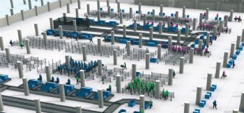
The software managing our city movementFor those working in architecture and urban planning, this is one type of software that is often used. It is capable of simulating the behaviour of thousands of people so that they can be imported into digital models of city spaces.
The simulated agents can act intelligently according to set guidelines. This can be used in several ways. For architects designing a new building or arena that has the potential to host thousands of people, this technology could be used to simulate an evacuation for instance.
The crowd can be monitored to see what problems they encounter while attempting to escape the building.
To help plan emergency exit routes, this software can be used in the likes of transport links — from bus to train stations. With the rise of terror incidents across Europe, the use of crowd simulation and preparing for unlikely situations is more important than ever.
The rise of geographic information systems (GIS)Allowing architects to look at and manage geographical data, GIS can manipulate the results to better a project.
An advantage of this system is being able to complete multi-layer mapping activities. Similar to a density map, this feature allows the user to see a range of measures on one area.
For example, potential agricultural land, areas which are prone to flooding, and erodible land can all be visible on one map. This allows urban planners to visualise areas that would not be suitable for building on.
These systems are able to hold records of building permits that show issues that could potentially be a threat to new plans. The success of potential businesses can be analysed too by measuring their proximity to potential competitors and customers.
So, what is building information modelling (BIM)?When building structures are proposed, BIM systems allow architectures to be visually present within the appropriate environment. This technology is becoming more important in the design of ‘smart cities’, to test out the impact of the building before construction goes ahead.
If a project is proposed to be built on an already established location, challenges could present themselves. However, BIM can inform system managers of a wide range of factors.
For example, the software could show how deep to dig in order to not crash into a fibre optic cable.
A key feature of BIM is the option to enable collaborations — with all designers on the project. For example, workers on drainage construction and landscaping can consult the same model to help better inform their decisions.
Tony Andrews from Bentley Systems, after working on the Crossrail Project, said: “Some of the drilling that we did for this project was within centimetres of the existing underground tunnels in London. It was absolutely incredible.”
What are the next steps?With advancements in technology, there are many new software packages that are coming into use for urban planning projects. One of these — not used for urban planning yet — is open-source software that has been developed in New York.
It is currently a system that creates a map using data to visualise how people move through cities. Heat spots on the map become more intense when areas are popular.
With results that allow management to see who is occupying city spaces and how they are being used — this technology is a revolution for the building world.
At the moment, the data is collected from Flickr and Twitter uploads, and this is planned to expand to other social networks.
Looking to the future, it could potentially be used to look at software cities in real time. It will also be possible to make comparisons between cities and replicate planning of structures if it has been successful in a city elsewhere.