Scientists from the Universities of Aberdeen (
www.abdn.ac.uk) and Oslo (
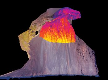
www.uio.no) have created the world’s first 3-D thermal image of an active volcano (Stromboli in Italy), using drone technology.
John Howell at the University of Aberdeen said: “Our technique involves using drones to take hundreds of aerial photographs and putting these together to create a 3-D model that maps the surface. We can then overlay the model with images from a thermal camera, allowing us to see the thermal structure of the volcano in 3-D.
“This gives us an insight into changes in the volcano. If certain areas are unexpectedly hot, it might be an early warning sign, especially if the ground has swelled.
These are very small movements, but by using the latest high-precision cameras, we can notice subtle changes to the volcano that might signal an imminent eruption.
"The ability to deploy a drone really close to a volcano means that we can also deploy portable seismometers and gas sensors in areas that are too dangerous for people.
“Drone technology is moving so fast that we could have a system fully up and running in a few years.
“Being able to send a low-cost portable drone unit to any volcano around the world could really revolutionise how we monitor volcanos, and it could be a game-changer for the people who live and work in their shadow.”