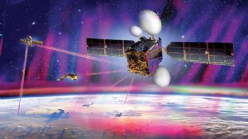
The EDRS-C satellite, the second node of the SpaceDataHighway network, was launched into geostationary orbit by an Ariane 5 rocket from Kourou (French Guiana) earlier this month.
After being tested and commissioned, it will join EDRS-A, which transmits on a daily basis the images of Earth acquired by the Copernicus programme’s four Sentinel observation satellites.
Since it entered service in late 2016, it has achieved more than 20,000 ‘laser connections’ (the reliability rate has reached 99.5%), and these have been used to download more than 1 petabyte (one thousand million million) of data.
Full operation of the system, including EDRS-C, is expected by the end of 2019.
The SpaceDataHighway is the world’s first ‘optical fibre’ network in the sky based on ‘cutting edge’ laser technology. It comprises a network of geostationary satellites positioned above a network of ground stations that can transmit data at 1.8Gbit/sec.
It will be a key component of the Airbus Network for the Sky (NFTS) programme.
This combines various technologies — satellite and ground communications, air-to-ground, ground-to-air and air-to-air tactical links, 5G mobile communications and laser connections — in a “resilient, unified, secure and highly interoperable mesh network” for aircraft, UAVs and helicopters.
A third communication node will be positioned over the Asia-Pacific region by around 2024.
Equipped with three laser terminals, EDRS-D will significantly increase the system’s communication capacity and considerably expand its coverage.